ESRI Urban Observatory- the right model for city crowdsourcing?

This month ESRI made an interesting move into the field of global city data with the launch of Urban Observatory (TM). The site has some great interactive visualisation ideas with simultaneous mapping of three interchangeable cities, linked navigation and indicator selection. It provides an intuitive interface to explore the diverse forms of world cities-

UrbanObservatory

Furthermore this ambitious project is intended to be an extensible platform. Jack Dangermond (billionaire founder of ESRI) and Richard Saul Wurman (founder of TED with a long-standing interest in city cartography) discuss in the introductory video how they want many more cities to join in, to crowdsource city data from around the world, using the ArcGIS online platform.

So is this project going to be the answer for all our global urban and smart city data needs? Well I think despite the great interface, as a city crowdsourcing model ESRI’s urban observatory is not going to work. But it’s interesting to explore why, particularly in relation to the bigger questions of whether the open city data revolution is going to be truly global and inspire a new era of urban analysis and comparative urban research.

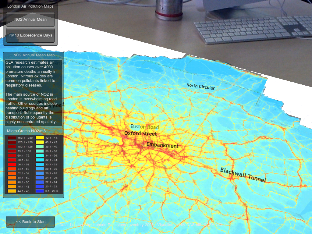
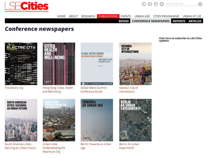
ESRI’s site states that “information about urbanization does not exist in comparative form”. In reality comparative urban analysis is a growing trend across many sectors, from international organisations like OECD, EU and UN (including the original UN Habitat Urban Observatory); to environmental organisations like ICLEI and C40; to economically focussed organisations like the World Bank and Brookings; to global remote sensing providers like the USGS; to major commercial data producers in transport and telecoms; to the many urban academic research centres around the world (including the two London based centres I’ve worked for, CASA and LSE Cities).

Global cities data example- GaWC Network at Loughborough
CASA- deprivation in UK cities example.
Brookings MetroMonitor- comparison of US cities' economic performance
Brookings MetroMonitor- comparison of US cities’ economic performance


LSE Cities- over a decade exploring comparative urbanism

There’s a rich and growing field of data providers and analysis techniques to draw on for comparative urban analysis. Indeed the ability to gather and analyse urban data is absolutely central to the whole Smart City agenda. But there are clearly many challenges. What do cities gain by opening up their data? Who then owns the data and controls how it is presented? Who selects what data is included and excluded?

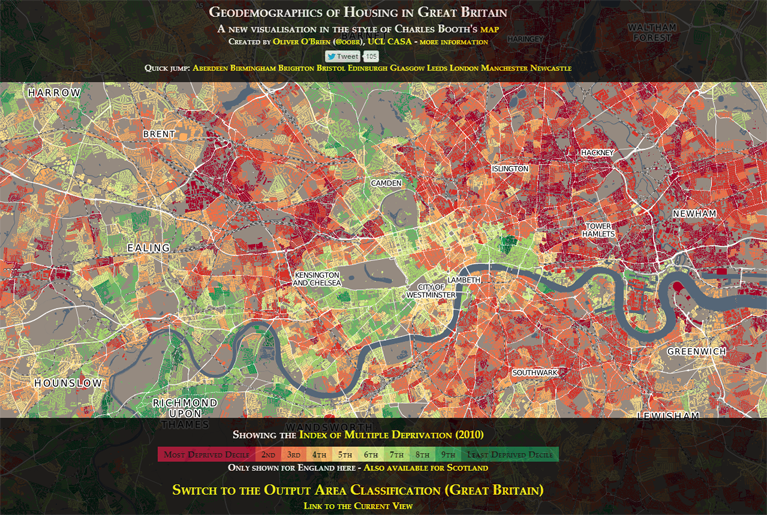
I believe the natural platform for civic data (and subsequently for the international comparison of urban data) will be an open platform with wiki features to encourage civic engagement. This provides the answers to the above questions- citizens gain from better access to data and institutional transparency; citizens own the data and have a say in what is included and how it’s presented. This is the model for current successful open data sites like the London Datastore, where anyone can access the data, and Londoners can request new datasets (backed by freedom of information legislation). Unfortunately the governance situation is of course much more complicated for the international comparison of cities, and this has limited progress.

As the world’s leading provider of GIS software, ESRI are in a strong position to integrate global datasets, and have clear commercial interests in amassing urban data for their clients. But it’s much harder to answer questions about who owns and controls data in their urban observatory project. Arguably this will limit the number of cities volunteering to take part, and limits the project’s ability to respond to the diverse demands of global cities and their citizens.

A further huge challenge in comparative urbanism is in developing the right analytical techniques and indicators to answer key urban questions. This will inevitably require more sophisticated analysis tools than a set of thematic maps, and needs to draw on the many research strands developing the most relevant analytical tools.

Overall there will be some exciting competition in the coming months and years in the expanding market of international urban data integration and visualisation, with different models from commercial, government and academic contexts. ESRI’s urban observatory is an innovative project, and should stimulate further advances.

Sparks of Inspiration at the Electric City Conference

UAECC_7Dec_103
Michael Kimmelman, Bjarke Ingels, Ricky Burdett and Alejandro Zaera-Polo debate urban design

You know you’ve attended a good conference when the discussion leaves your head buzzing with new ideas and possibilities, and the debate continues long after the event closes. This was certainly the case at the Urban Age Electric City conference last week, where politicians, academics, designers and technologists met to share, discuss and argue urban policy and the future of cities.

Ostensibly the conference theme was smart cities and urban technology, and there were several tech business speakers extolling the virtues of electric cars, smart grids and so on. There was however widespread cynicism of techno-fixes on many fronts. Adam Greenfield used the very definitions of the smart city provided by corporate promoters to show the vacuous techno-utopian branding of what is often simply an extension of the real-estate industry. Richard Sennett articulated the ambiguous and complex nature of traditional street-based urban form, and by extension how archetypal smart-city examples from Masdar and Songdu failed to create similar spaces of social interaction that support innovation.

Yet it must be said that the urban technology debate is itself far more diverse than the strawman examples of Masdar and Songdu. Certainly the Shoreditch digital economy cluster that surrounds the conference venue illustrates thriving tech businesses in a traditional urban setting. Many of the counterexamples to smart-city utopia presented during the conference themselves involved aspects of technology, particularly in relation to communication and participation.

Urban equity, or lack of, was a key theme for many speakers. Enrique Peñalosa, former mayor of Bogotá, passionately argued for tackling social inequality as a central element of improving urban sustainability- an argument he has helped translate into reality through reforming Bogotá’s public transport networks. The politics of inequality also underlie the social movements and protests that have rocked the world, from Occupy to the Arab Spring and the London riots. In these cases social networking technology presents a highly dynamic and unpredictable force that city governments, both rich and poor, are struggling to engage with.

On the design front, the talk that best integrated the conference themes was from Alejandro Zaera-Polo, who sought to articulate the evolution of architectural style and practice in response to digital communication. Citing modular and self-build architecture examples, he described a new aesthetic of incompleteness, and used slum developments as the model of how complex functional urban form emerges from simple building blocks. He also pointed to crowdsourcing as an increasingly key funding mechanism for development in the austerity age, requiring a new entrepreneurialism from architects to generate public support and money for ambitious projects. This spirit of architectural daring and entrepreneurialism was certainly on show from Bjarke Ingels, whose mad and wonderful “hedonistic sustainability” examples were a joy to see.

Alejandro Zaera-Polo- "architects must create belief"
Alejandro Zaera-Polo- “architects must create belief”

Yet as much the designers inspired, presentations tackling the global environment highlighted the gaping chasm between urban sustainability aspirations and reality. “Cities dream of Barcelona and build Los Angeles” was Greg Clark’s quick-fire summary of Joan Clos’s conclusions from the UN Human Settlements Programme. “The compact city plus global lives do not equal sustainability” correctly argued Maartin Hajer.

Intellectual heavyweight Anthony Giddens grappled with the grave implications of the 4+ degrees warming path we are set on for this century, and the high-risk high-opportunity civilisation we have created. When asked somewhat glibly by the chair whether he was an “optimist or a pessimist” he replied quite rightly that the question was irrelevant and that climate change requires scientific realism, a perspective that is currently beyond much of the public. It’s certainly appeared beyond the UK politicians on show, who enthusiastically banged the drum for sustainable London while conveniently forgetting that much of the globe’s fossil fuel industry in headquartered in London and funded by City banks.

Anthony Giddens tackles the implications of global climate change

There were also some rays of hope for a deeper understanding of urban sustainability. The former mayor of Stockholm, Carl Cederschiöld, described how sustainability progress had been achieved in his city, pointing to the vital role of both strong national support and public understanding as well as city government. Dimitri Zenghelis put forward the economic growth case for an urban green transformation. Mark Swilling presented a methodology of understanding urban sustainability through social and resource flows- exactly the kind of approach needed for considering sustainability in an age of global connectivity. Maartin Hajer described the need for forging “coalitions of the willing” in tackling global sustainability where international governance has been so ineffective.

And that’s what the Urban Age conference surely is in the end, one big coalition of the willing… or willing to discuss and debate at any rate. Thanks to all those who took part and contributed to a very engaging event. If you missed it, conference video highlights will be appearing on the website over the coming days, and you can read essays by many of these speakers in the conference newspaper.

Urban Age Electric City Conference

ElectricCity

I recently began a new job at LSE Cities and have been working for the last month on materials for the Electric City conference in London, taking place on the 6th and 7th December this week. The conference will be exploring smart cities and disruptive urban tech from a sociological slant, and includes talks from famous urbanists such as Ed Glaeser, Saskia Sassen and Deyan Sudjic. You can get a flavour of the debate from Richard Sennett’s provocative article on “Stupefying Smart Cities”.

The whole event will be live streamed on the conference website.

My role, alongside the LSE Cities Research Team, has been in producing comparative urban visualisations and analysis around the theme of sustainable urbanism. These visuals and articles are now online in the conference newspaper.

Automobile 2.0: Electrification, Sharing and Self-Drive

Autonomous car concept by Mike and Maaike.


Despite the litany of sins levelled at the automobile- it’s woeful energy efficiency, harmful pollution, congestion, road casualties, damage to public space, contribution to obesity- we are still wedded to the car. In the UK the car accounts for over three quarters of trip miles. The flexibility, security and door-to-door convenience of automobile travel remains a winning combination, particularly when we spent most of the 20th century developing car-based cities with limited alternatives.

Current planning practice restricts car travel to improve sustainability and urban quality of life. Short of an outright ban however, the car is here to stay in some form or other.

For the automobile to be in any way sustainable we need to radically challenge current systems of car design, driving and ownership to effectively create a new mode of transport. This post considers whether such a revolution is possible in light of exciting recent innovations.

Electrification
We now for the first time have competitive alternatives to the internal combustion engine car on the market with electric and hybrid models from the world’s biggest manufacturers. These technologies dramatically reduce or remove tail-pipe emissions. Surely then the eco-car has now arrived and city transport has been saved?

Nissan Leaf plugport


Well… as electric cars (and vans/taxis/buses) become more widespread urban air quality should improve dramatically, as should vehicle mileages. But as we generate the majority of electricity using fossil fuels (and will continue to do so for the next 20 years+), CO2 emissions from electric cars remain significant.

Furthermore several other car design issues are not solved by electrification, such as energy used in manufacture, road congestion, safety and damage to public space. There’s a danger that electric cars become merely a green-wash cover for business as usual, rather than as a step towards bigger change.

Sharing
Most cars are driven for a relatively short period each day, and are parked the rest of the time occupying land (around 10% in cities). On-street parking eats up large amounts of valuable public space from pedestrians, public transport and cyclists. It’s a wasteful situation, both for the efficiency of cities and for the environment due to the vast amounts of materials and energy used to manufacture our largely idle cars.

One increasingly popular solution in cities is car-sharing, with the largest company Zipcar now up to 700,000 members. Car-sharing is a convenient and affordable option for many city residents who want regular car access without the hassles of ownership. The popularity of smartphones provides an easy way to manage car-share booking. Comparable sharing trends are also evident for ride-sharing and for urban cycling.

Is sharing the answer then to the sustainable city travel? It’s definitely an important trend. Sharing allows a much better pricing model for driving, paying by the mile and charging more at peak times, thus encouraging more efficient behaviour.

Car-sharing coverage is limited however to denser urban areas, and it is not yet clear to what extent car-sharing can significantly reduce the total number of vehicles and car parking space in cities.

Self-Drive
The last trend is at a much earlier stage than electrification and car-sharing, yet it could have the most far-reaching consequences. Sat-nav and parking-assist technologies were early steps towards greater automation in cars. Now Google as well as several manufactures have working prototypes of autonomous or self-driving vehicles.

Amazing yes, but what’s the point? In its current form, the application of this technology is not immediately clear, beyond providing a luxury car gizmo that lets you read the paper while your car drives you to work. But future developments will likely involve cars built around self-drive from the ground-up.

Potentially you could have a city taxi fleet of fully autonomous electric cars, requested by smartphone, operating 24 hours a day, moving to areas of high demand, charging batteries when not in use. Whilst bad news for taxi-drivers, such a system could be highly efficient and provide a quick and flexible complement to mass transit networks.

A related concept has already been developed in a rail-pod form operating at Heathrow airport. Dubbed Personal Rapid Transit, it is intended to combine the advantages of both private and public transport. Obviously the challenges of converting such a system to operate autonomously in the ‘wild’ of the urban environment are many, yet are increasingly being tackled.

If such a system could safely and legally operate, the implications would be massive. Imagine freight and courier services operating automatically at night to minimise disruption; your car picking up your shopping on its own, or taking a nap and waking up at your destination.

Reality Check
It’s easy to get carried away with the wonders of new technology. Transport challenges require political and economic solutions as much as technological brilliance. Indeed relying on car manufacturers alone to green transport is as unlikely as “Beyond Petroleum” BP and Shell delivering the renewable energy revolution. Yet there is some incredible innovation currently emerging, and the next couple of decades are certain to be very interesting times for urban transport.


London 3D Augmented Reality Map

CASA hosted a very successful Smart Cities event last Friday, including presentations from Carlo Ratti, Mike Batty and Andy Hudson-Smith. The event premiered an interactive exhibition we have been working on, based on the theme of mixing physical and digital worlds. Some fantastic and fun exhibits have been developed by colleagues including George MacKerron, Steven GrayOllie O’Brien, Fabian Neuhaus, James Cheshire, Richard MiltonMartin de Jode, Ralph BarthelJon Reades, Hannah Fry, Toby DaviesPete Ferguson and Martin Austwick, who no doubt will be blogging about them all soon. Thanks to everyone who attended and contributed to a great day.

For my own exhibit I had a try at developing an augmented reality app to explore 3D urban data. The idea was to use iPads as the window into a 3D urban map of London, allowing the user to navigate around the virtual model to see different perspectives and focus on interesting parts of the data. Do we respond differently to data with a seemingly physical presence? Well this is one way to find out…

The app was developed in Unity using the Vuforia AR extension, and I was impressed with how accessible augmented reality technology has become using such tools. Firstly GIS data on urban form in London and air pollution was exported from ArcMap into Unity, and an interface to the data was developed. The core app without the AR capabilities can be viewed here (Unity web player required).

Next I followed the Vuforia iOS tutorials to add AR functionality. This approach uses a tracking image to position and scale the 3D model to the user’s viewpoint. Nice features of Vuforia include the ability to select your own tracking image, and that it can handle some occlusion of the image when the user moves to a particular part of the model, although a part of the tracking image must be in view of the camera at all times otherwise the model disappears from the user’s view. A large A0 poster was used as the tracking image, giving users greater flexibility in navigating the data.

The resulting app is very intuitive and delivered the desired ‘wow’ factor with many of the attendees at the conference. The AR aspect certainly encouraged users to explore the data, and identify patterns at different scales.

Adding more interactivity, animation and sorting out some issues with the target image (multiple smaller images would have worked better than one very large image) would all be nice for version 2. I’ll do a more detailed tutorial on the workflow developed later on if this is of interest.